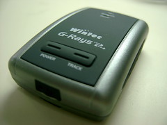
I have dreamed to have a GPS equipped digital camera for a long time, that I can record geographic information in my photos. But in recent years, such a product seemed not to be accepted by people, and there are not many products in the marketplace.
After several corporations launched online map services, such as Google Maps and much localized for Taiwan, UrMap, many applications based on them poped up. And then, GeoTagging attracted me, but it’s so inconvenient to add geotags on a photo by pulling the photo on a map. That’s time consuming and not accurate very much. After I read the article “A GPS Receiver Which Is Not Only A Bluetooth GPS Receiver,” I had realized this is what I want.
I bought one on Mobile01 because there’s no sweeter price on Y!Bid. And after a-whole-day-trying, the gadget could fulfill most of my desires. Although the software Time Machine X is not user friendly and the efficiency of adding geo-info is just acceptable, I still felt satisfied while seeing the tracing path and correctly located photos showing in Google Earth.
The problem remained may be to find a more easy way to combine the tracing info and the geotagged photos and convert to whether a Google Earth KML/KMZ file or a HTML page based on UrMap or Google Maps API. It’s just a start for my incoming travelling map. :)

Pingback: Tsai I-Ta’s Blog » Vim - What A Nice Editor